The Rappahannock River
"Lappihanne" - Where the Water Rises and Falls
The name "Rappahannock" derives from the Algonquian word lappihanne, meaning "river of quick, rising water" or "where the tide ebbs and flows." This reflects the river's tidal nature and its importance in the daily lives and spiritual practices of Indigenous peoples.
For thousands of years before European colonization, the fall line served as a sacred nexus where the physical and spiritual worlds converged. Here, where ancient Piedmont rocks meet the Coastal Plain, Indigenous peoples created an astronomical calendar and spiritual complex that rivals the great sacred sites of the world.
The Sacred River Corridor Theory
🌟 Astronomical Calendar
The petroglyphs and rock formations align with solar, lunar, and stellar events, creating a sophisticated timekeeping system that guided seasonal activities for millennia.
🐍 Snake Rock Guardian
The serpent petroglyph at Snake Rock serves as both a drought indicator and a spiritual guardian, emerging fully when water levels drop to signal environmental changes.
🏛️ Ceremonial Complex
The Indian Punch Bowl, Overlook, Recess Pool, and petroglyphs form an integrated sacred landscape where different tribal groups gathered for ceremonies and resource sharing.
🌊 Nature's Rolex
Like an expensive timepiece, this natural and enhanced landscape served as a precise instrument for tracking time, seasons, and celestial events.
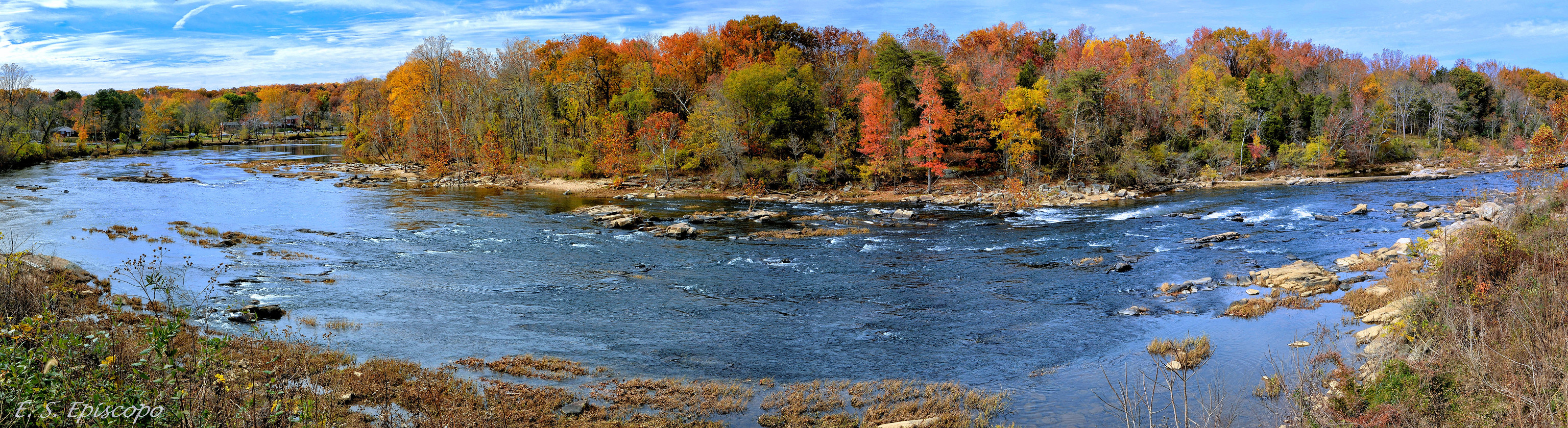
The Convergence of Waters, Peoples, and Worlds
At European contact, the fall line marked a cultural frontier between Algonquian-speaking peoples organized under Wahunsenacawh's (Powhatan's) confederation in the east, and Siouan-speaking groups including the Manahoac confederation in the west. The fall line functioned as both boundary and meeting ground—a liminal zone where different worlds touched and where the thundering rapids, swirling pools, and mist-shrouded rocks were understood as dwelling places of powerful spirits.
🏝️ The Sacred Islands
Hunter Island / Lauck's Island
Historically known as Hunter's Island, this area was utilized for various industrial purposes, including ironworks and milling operations in the 18th and 19th centuries. Ownership changed hands multiple times, and the island was eventually abandoned after a significant flood in 1937. Yet beneath this industrial overlay lies evidence of much deeper occupation, including possible traces of Ice Age encounters and the earliest human presence at the fall line.
Ficklen Island
Located near Fredericksburg, Ficklen Island housed the Bridgewater Mill established in 1822. Its proximity to known Indigenous sites suggests it may have also held significance for Native American communities, potentially serving as a location for fishing, gathering, or ceremonial practices. The island's elevated bedrock formations created natural refuges amid the rapids, making it an ideal staging ground for seasonal activities.
The Mysteries of the River
Nature's Rolex: The Sacred River Corridor Theory
The Rappahannock fall line reveals itself as one of the most sophisticated astronomical and environmental monitoring systems ever created. Like an expensive timepiece, this natural and enhanced landscape served as a precise instrument for tracking time, seasons, celestial events, and environmental changes across millennia.
🌟 The Astronomical Calendar System
The positioning and alignment of the sacred sites create a comprehensive observatory for tracking solar, lunar, and stellar cycles essential to Indigenous agricultural, ceremonial, and navigation systems.
Solar Observatory Functions
🌅 Equinox Alignments
The river's east-west orientation provides natural baselines for solar observations. During spring and fall equinoxes, the sun rises almost directly over the river's eastern reach, creating dramatic light paths visible from the Overlook.
☀️ Summer Solstice
Northeast sunrise aligns with Snake Rock position relative to other sites. The longest day marked peak fishing season and major ceremonial gatherings.
🌄 Winter Solstice
Southeast sunrise aligns with downstream river course toward Chesapeake Bay, marking the return of light and beginning of the ceremonial year.